In 1967 a group of specialists transferred from the Moscow Institute for Geodesy, Aerial Photosurveying and Cartography to the newly established Space Research Institute of the USSR Academy of Sciences. This group began work on space research in the visible and near infrared bands of the electromagnetic spectrum, on the creation of unique onboard instrumentation, on studies of the Earth and other bodies of the Solar system from spacecraft (SC) as well as on the development of algorithms and programs to process and analyze the space image data acquired.
In 1972 this group became the core of the new Department of Earth research from space. In 1980 the department's name was altered to the Department of optico-physical measurements (Optico-physical department).
Yan L. Ziman
founded and headed the Department.
Studies of the Lunar surface topography and relief, based on TV-images from the Lunokhod-1 and 2.
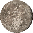
Review of dimensions and the shape of the celestial body based on photo-television images of the far side of the Moon acquired from the automated interplanetary station “Zond”.
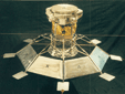
“Lunokhod-1”
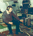
Conducting an experiment on synchronous photoimaging of the starry sky and the terrestrial surface from the first manned orbital station “Salyut” was conducted for testing the technique of precision determination of the SC attitude parameters and space imagery referencing.
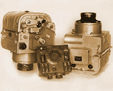
Modernized aerial photocameras AFA BA-210 were used for imaging.
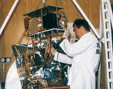
Creation of an aircraft lab based on the IL-14 and AN-30 airplanes for processing the techniques of multi-spectral photographic and optico-electronic aeroimaging to simulate Earth imaging from space.
Development of the software for processing and thematic interpretation of the acquired image spectrometric data for solving the Earth sciences tasks.
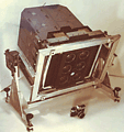
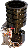
Development of the space photo-camera MKF-6 together with German specialists and its flight test on-board the “Soyuz-22” spaceship.
Testing the technique of thematic interpretation of multi-spectral space images in cooperation with specialists from the Moscow State University.
Introduction of the MKF-6 camera in the practice of imaging the Earth surface from manned orbital stations for economic and Earth sciences purposes.
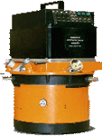
Development of the first Russian scanning eight-band digital TV-system “Fragment” and its operation testing for four years on the “Meteor-Priroda” SC.
Digital processing and thematic interpretation of the downlinked image data.
Development of the CCD-based television system “VEGA” for imaging the comet and its nucleus from the automated interplanetary stations “VEGA-1 and 2”. The TV-system was designed in cooperation with Hungarian and French specialists.
Participation in the creation of the platform for the imaging system.
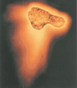
Processing of the images acquired made it possible to determine the nucleus shape and dimensions, to define more precisely the structure, absolute brightness values and photometric characteristics of its surface and jets. In addition photometric characteristics were calculated and the comet's tomographic reconstruction was made possible.
Creation in cooperation with German specialists of the ASTRO system integrating CCD-based star trackers and onboard processor. The ASTRO system was used for the “Mir” orbital station attitude determination by TV images of the starry sky.
The ASTRO system operated on-board the orbital station for more than ten years untill its sunk in 2001.
Creation of the imaging spectrometric system “Fregat” in cooperation with Bulgarian and German specialists.
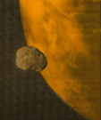
The images acquired by the interplanetary station “Phobos” were used for studying the photometric and spectral characteristics of the Phobos surface. In addition its geological maps and internal structure were defined more precisely.
Development of a theory of SC stabilization with solar light pressure.
A base model of the small spacecraft “Regatta” with a solar sail providing for precise attitude stabilization of its longitudinal rolling relative the direction towards the Sun was designed.
Three modifications of this small spacecraft were proposed – for astrometry, solar terrestrial physics as well as Sun observation and Solar activity patrol
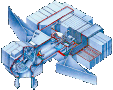
Creation of the “Argus” platform for studying the Martian surface and atmosphere with two multispectral TV-systems, developed in cooperation with German specialists and the Navigation camera. The latter became the first compact star coordinator. The “Mars-96” SC sank in the Paci-fic Ocean after a failed launch.
Development of, and introduction to space flight practice, the BOKZ star trackers. These instruments are operating in the attitude control circuit of the International Space Station, the Yamal, Resurs-DK and other s/c.
Development and manufacture of digital aerial imaging cameras prototypes - TsTK-140 and TsMK-70 - based on space technologies. TsTK-140 camera has been developed for b&w topographic stereo imaging. TsMK-70 camera allows for simultaneous imaging in four spectral bands (RGB and near IR).
Development of and manufacture of multiband imaging systems for studying land and water surfaces from onboard the weather and remote sensing s/c.

Development of onboard systems for the “Phobos-Grunt” mission to solve the navigation tasks, study Mars and Phobos as well as to control the scientific payload.
1970-1972
"Salyut" orbital station attitude determination
1973-1982
Flying laboratory
1974-1978
"Raduga" experiment
1978-1984
"Fragment" experiment
1980-1986
Halley's Comet Studies
1981-2001
Sytem of "Astro" star trackers
1986-1989
"Phobos" project
1987-1991
"Regatta" project
1989-1996
"Mars-96" mission
1997-2011
High precision s/c attitude control
2004-2008
Digital aerocameras
2004-2009
Multiband imaging cameras for Earth remote sensing
2005-2011
Developments for the "Phobos-Grunt" mission